
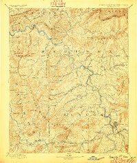
1894 Map of Asheville
USGS Topo · Published 1894About this map
Asheville and its surrounding mountain communities are captured in this late 19th-century survey, revealing a landscape defined by the serpentine course of the French Broad River. The Western North Carolina Railroad serves as a critical artery, threading through the river gorge and connecting settlements like Marshall, Alexander, and Hot Springs. To the south, the railroad follows the Pigeon River through Canton and Clyde, illustrating the region's burgeoning transport network before the era of modern highways. Local industry and social hubs are evident in the placement of several family-owned operations, such as Gudgers Mill and Wells Mill, alongside recreation-focused sites like Sulphur Springs. The map also meticulously delineates the high ridges of the New Found Mountains and Walnut Mountains, highlighting the geographic barriers that shaped early North Carolina and Tennessee settlement patterns.
Find a feature on this map
144 named features on this map. Tap any name to fly to it.
Don’t see what you’re looking for? This feature index may not catch every label — zoom into the map to look around manually.
Map Details
Editions of this 1894 Asheville Map
2 editions found
Other maps of this area

1883 · Morristown
USGS Topo · 1:125,000

1891 · Cowee
USGS Topo · 1:125,000

1891 · Roan Mountain
USGS Topo · 1:125,000

1892 · Greeneville
USGS Topo · 1:125,000

1893 · Mt Guyot
USGS Topo · 1:125,000

1893 · Morristown
USGS Topo · 1:125,000

1894 · Roan Mountain
USGS Topo · 1:125,000

1895 · Morristown
USGS Topo · 1:125,000

1896 · Greeneville
USGS Topo · 1:125,000

1897 · Cowee
USGS Topo · 1:125,000