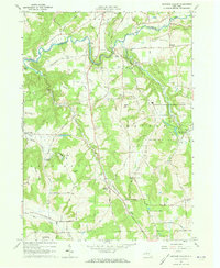
1964 Map of Ashford Hollow
USGS Topo · Published 1973About this map
The deep gorge of Zoar Valley cuts across the northern landscape of this mid-century survey, where Cattaraugus Creek serves as the boundary between Erie and Cattaraugus counties. The area is characterized by high, named summits like Cobble Knob and Mount Tug that separate small rural settlements and dairy farming valleys. The 1960s footprint of the Western New York Nuclear Service Center occupies the eastern portion of the map, marking a significant industrial presence in an otherwise agricultural region. Genealogists will find a high density of small family and community burial grounds, including the Weber Cem, Thomas Corners Cem, and Franktown Cem. Transportation patterns are anchored by rural junctions like Ashford Hollow and Thomas Corners, while the rail influence is noted at Edies Siding and Riceville Station.
Find a feature on this map
58 named features on this map. Tap any name to fly to it.
Don’t see what you’re looking for? This feature index may not catch every label — zoom into the map to look around manually.
Map Details
Editions of this 1964 Ashford Hollow Map
4 editions found
Other maps of this area

1905 · Eden
USGS Topo · 1:62,500

1907 · Eden
USGS Topo · 1:62,500

1923 · Cattaraugus
USGS Topo · 1:62,500

1924 · Ellicottville
USGS Topo · 1:62,500

1925 · Springville
USGS Topo · 1:62,500

1938 · Cattaraugus
USGS Topo · 1:62,500

1941 · Cattaraugus
USGS Topo · 1:62,500

1941 · Ellicottville
USGS Topo · 1:62,500

1944 · Eden
USGS Topo · 1:62,500

1944 · Langford
USGS Topo · 1:31,680