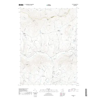
2019 Map of Ashland
USGS Topo · Published 2019About this map
Batavia Kill winds through this mountainous section of the Catskills, anchoring the small settlements of Ashland and Jewett. The 2019 landscape is defined by its deep cemeteries, which provide a genealogical roadmap for families tied to the area, including West Settlement Cem, Sutton Hollow Cem, and the Jewett Heights Cem. The terrain is dominated by significant peaks such as Lost Mountain and Ashland Pinnacle, while the boundary between Schoharie and Greene counties cuts across the high ridges of South Mountain. This modern survey reveals how local roads like County Road 10 and County Road 12 still follow the natural contours of the hollows, connecting smaller hamlets like West Settlement and North Settlement to the larger valley corridors. Researchers will find a mix of agricultural legacies and newer developments like Windham Mount Village clinging to the steep slopes of Cave Mountain.
Find a feature on this map
112 named features on this map. Tap any name to fly to it.
Don’t see what you’re looking for? This feature index may not catch every label — zoom into the map to look around manually.
Map Details
Editions of this 2019 Ashland Map
This is the sole edition of this map. No revisions or reprints were ever made.
Other maps of this area

1892 · Kaaterskill
USGS Topo · 1:62,500

1893 · Kaaterskill
USGS Topo · 1:62,500

1893 · Durham
USGS Topo · 1:62,500

1894 · Kaaterskill
USGS Topo · 1:62,500

1894 · Durham
USGS Topo · 1:62,500

1899 · Kaaterskill
USGS Topo · 1:62,500

1900 · Phoenicia
USGS Topo · 1:62,500

1901 · Gilboa
USGS Topo · 1:62,500

1903 · Gilboa
USGS Topo · 1:62,500

1903 · Phoenicia
USGS Topo · 1:62,500