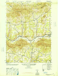
1946 Map of Ashland
USGS Topo · Published 1946About this map
Catskill State Park encompasses the southern portion of this mid-century survey, where the peaks of Tower Mtn and Cave Mountain overlook the high valleys of the Northern Catskills. The settlement patterns follow the winding path of Batavia Kill and East Kill, with the village of Ashland serving as a central point for a series of remote upland communities. The landscape is defined by its family-named hollows and peaks, such as Sutton Hollow and Ashland Pinnacle, which reflect the area's long-standing agricultural and residential history.
Find a feature on this map
43 named features on this map. Tap any name to fly to it.
Don’t see what you’re looking for? This feature index may not catch every label — zoom into the map to look around manually.
Map Details
Editions of this 1946 Ashland Map
This is the sole edition of this map. No revisions or reprints were ever made.
Other maps of this area

1892 · Kaaterskill
USGS Topo · 1:62,500

1893 · Kaaterskill
USGS Topo · 1:62,500

1893 · Durham
USGS Topo · 1:62,500

1894 · Kaaterskill
USGS Topo · 1:62,500

1894 · Durham
USGS Topo · 1:62,500

1899 · Kaaterskill
USGS Topo · 1:62,500

1900 · Phoenicia
USGS Topo · 1:62,500

1901 · Gilboa
USGS Topo · 1:62,500

1903 · Gilboa
USGS Topo · 1:62,500

1903 · Phoenicia
USGS Topo · 1:62,500