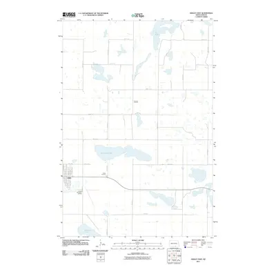
2011 Map of Ashley East
USGS Topo · Published 2011About this map
Ashley serves as the primary hub of this prairie landscape, situated near the intersection of a strictly gridded section-line road network. The town's layout is meticulously detailed, showing the street grid from Center Ave N to 3rd Ave NE. To the south, the Ashley Municipal Airfield provides a modern link to this agrarian region, while the local geography is defined by numerous glacial depressions. Prominent water bodies such as Kislingburg Lake and Salt Lake dot the terrain, illustrating the hydrologic character of the Missouri Coteau region. For those researching family history, both Ashley Cemetery and the more remote Emmans Cemetery are documented in their exact locations relative to the township lines. The survey also traces the path of several rural routes, including 50th Ave SE and 93rd St SE, which provide the backbone for the surrounding farmsteads.
Find a feature on this map
32 named features on this map. Tap any name to fly to it.
Don’t see what you’re looking for? This feature index may not catch every label — zoom into the map to look around manually.
Map Details
Editions of this 2011 Ashley East Map
This is the sole edition of this map. No revisions or reprints were ever made.
Other maps of this area

1953 · Jamestown
USGS Topo · 1:250,000

1954 · Aberdeen
USGS Topo · 1:250,000

1956 · Aberdeen
USGS Topo · 1:250,000

1956 · Jamestown
USGS Topo · 1:250,000

1968 · Long Lake NW
USGS Topo · 1:24,000

1978 · Wolff Lake
USGS Topo · 1:24,000

1978 · Schumacher Lake NE
USGS Topo · 1:24,000

1982 · Coldwater Lake NW
USGS Topo · 1:24,000

1982 · Danzig
USGS Topo · 1:24,000

1982 · Ashley East
USGS Topo · 1:24,000