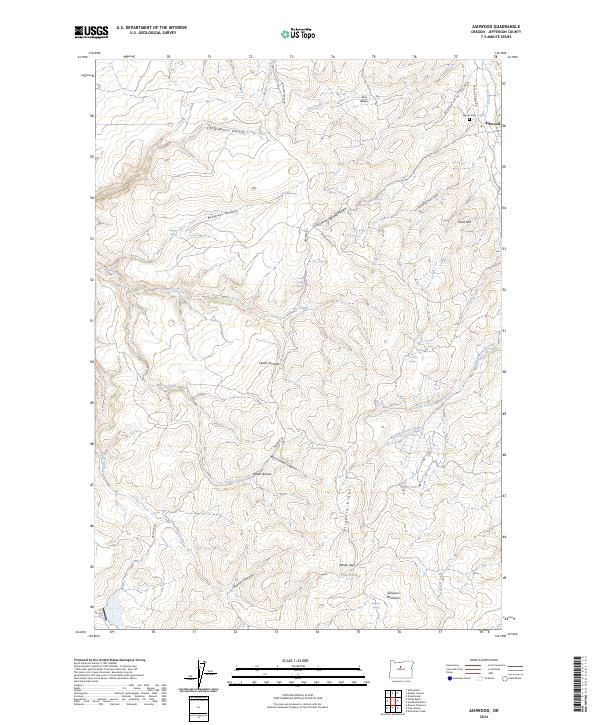
2024 Map of Ashwood
USGS Topo · Published 2024About this map
The settlement of Ashwood serves as the focal point for this high-desert landscape in Jefferson County, where steep drainage systems like Little Devils Canyon and Prineville Gulch carve through the volcanic terrain. This modern survey illustrates a landscape defined by its water sources, with numerous named springs such as Ryegrass Spring, McCorkle Spring, and Jump Spring supporting the local rangeland. The presence of Woods Cem near the town center and historical landmarks like Indian Arrows and Clarke Orchard provides tangible links to the area's agricultural and homesteading heritage. South of the townsite, the topography rises toward Blizzard Ridge and Sampson Mountain, separated by deep cuts like Rock Crusher Canyon and Rutter Canyon. The drainage of Trout Creek and Wilson Creek continues to dictate the orientation of local routes like NE Wilson Creek Rd, following the natural contours of the basin.
Find a feature on this map
47 named features on this map. Tap any name to fly to it.
Don’t see what you’re looking for? This feature index may not catch every label — zoom into the map to look around manually.
Map Details
Editions of this 2024 Ashwood Map
This is the sole edition of this map. No revisions or reprints were ever made.
Other maps of this area

1955 · Bend
USGS Topo · 1:250,000

1957 · Bend
USGS Topo · 1:250,000

1958 · Bend
USGS Topo · 1:250,000

1966 · Antelope
USGS Topo · 1:62,500

1966 · Willowdale
USGS Topo · 1:62,500

1968 · Axehandle Butte
USGS Topo · 1:24,000

1968 · Dutchman Creek
USGS Topo · 1:24,000

1968 · Ashwood
USGS Topo · 1:24,000
1969 · Brewer Reservoir
USGS Topo · 1:24,000
1969 · Foley Butte
USGS Topo · 1:24,000