
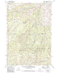
1968 Map of Dutchman Creek
USGS Topo · Published 1972About this map
Ochoco Mountains topography dominates this late-1960s survey along the border of Jefferson and Crook counties. The landscape is defined by a dense network of seasonal and year-round water sources essential for high-desert survival, including Ochittree Spring, Dutchman Spring, and the namesake Dutchman Creek. These water points, along with named terrain features like Boxcar Flats and Highland Flat, reveal the traditional movement patterns across the Ochoco National Forest before modern infrastructure reached these higher elevations.
Find a feature on this map
32 named features on this map. Tap any name to fly to it.
Don’t see what you’re looking for? This feature index may not catch every label — zoom into the map to look around manually.
Map Details
Editions of this 1968 Dutchman Creek Map
2 editions found
Other maps of this area

1948 · Ochoco Reservoir
USGS Topo · 1:62,500

1950 · Ochoco Reservoir
USGS Topo · 1:62,500

1955 · Bend
USGS Topo · 1:250,000

1957 · Bend
USGS Topo · 1:250,000

1958 · Bend
USGS Topo · 1:250,000

1962 · Prineville
USGS Topo · 1:62,500

1968 · Horse Heaven Creek
USGS Topo · 1:24,000

1968 · Axehandle Butte
USGS Topo · 1:24,000

1968 · Ashwood
USGS Topo · 1:24,000

1968 · Opal Mountain
USGS Topo · 1:24,000