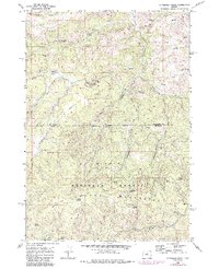
1968 Map of Dutchman Creek
USGS Topo · Published 1985About this map
Ochoco National Forest dominates this landscape along the border of Jefferson and Crook counties. The terrain is defined by a series of high ridges and deep drainages, including the headwaters of Beaver Creek and Trout Creek. Local naming reflects the rugged nature of the high desert and mountain country, with features like Poison Hollow, Cat Mountain, and the broad expanse of Boxcar Flats. Small, localized settlements or outposts like Foley and Board are marked along private roads, indicating the sparse human footprint in this timber and grazing region during the late 1960s.
Find a feature on this map
36 named features on this map. Tap any name to fly to it.
Don’t see what you’re looking for? This feature index may not catch every label — zoom into the map to look around manually.
Map Details
Editions of this 1968 Dutchman Creek Map
2 editions found
Other maps of this area

1948 · Ochoco Reservoir
USGS Topo · 1:62,500

1950 · Ochoco Reservoir
USGS Topo · 1:62,500

1955 · Bend
USGS Topo · 1:250,000

1957 · Bend
USGS Topo · 1:250,000

1958 · Bend
USGS Topo · 1:250,000

1962 · Prineville
USGS Topo · 1:62,500

1968 · Horse Heaven Creek
USGS Topo · 1:24,000

1968 · Axehandle Butte
USGS Topo · 1:24,000

1968 · Dutchman Creek
USGS Topo · 1:24,000

1968 · Ashwood
USGS Topo · 1:24,000