
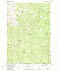
1968 Map of Opal Mountain
USGS Topo · Published 1973About this map
Roundup Grounds sits near the northern boundary of this high-elevation landscape, where the Ochoco Mountains define a terrain of deep gulches and seasonal springs. Mapped in the late 1960s, the area reflects a working wilderness characterized by seasonal livestock and logging operations. Evidence of this seasonal occupancy is found at the Trout Creek Cow Camp and Symons Wood Camp, as well as the remote Keller Cabin Spring.
Find a feature on this map
52 named features on this map. Tap any name to fly to it.
Don’t see what you’re looking for? This feature index may not catch every label — zoom into the map to look around manually.
Map Details
Editions of this 1968 Opal Mountain Map
2 editions found
Other maps of this area

1926 · Mitchell
USGS Topo · 1:125,000

1948 · Ochoco Reservoir
USGS Topo · 1:62,500

1950 · Ochoco Reservoir
USGS Topo · 1:62,500

1951 · Lookout Mtn
USGS Topo · 1:62,500

1955 · Bend
USGS Topo · 1:250,000

1957 · Bend
USGS Topo · 1:250,000

1958 · Bend
USGS Topo · 1:250,000

1968 · Horse Heaven Creek
USGS Topo · 1:24,000

1968 · Axehandle Butte
USGS Topo · 1:24,000

1968 · Dutchman Creek
USGS Topo · 1:24,000