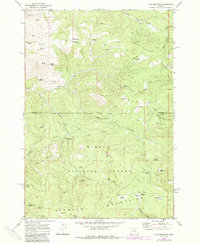
1968 Map of Opal Mountain
USGS Topo · Published 1985About this map
Ochoco Mountains terrain dominates this survey of the central Oregon highlands, where the boundary between Jefferson and Crook counties cuts through a landscape of ridges and high plateaus. The map documents a working wilderness, anchored by the volcanic prominence of Opal Mountain and the high elevations of Stephenson Mtn, which features a prominent Lookout Tower for fire surveillance. Settlement is restricted to seasonal outposts like Trout Creek Cow Camp and Symons Wood Camp, reflecting the area's history of timber management and livestock grazing. Named natural clearings such as Bingham Prairie and Moccasin Prairie offer a contrast to the dense network of drainages, including the North Fork and Opal Creek. The presence of the Roundup Grounds near Poison Hollow further illustrates the traditional ranching use of these federal lands within the Ochoco National Forest during the mid-to-late twentieth century.
Find a feature on this map
56 named features on this map. Tap any name to fly to it.
Don’t see what you’re looking for? This feature index may not catch every label — zoom into the map to look around manually.
Map Details
Editions of this 1968 Opal Mountain Map
2 editions found

Other maps of this area

1926 · Mitchell
USGS Topo · 1:125,000

1948 · Ochoco Reservoir
USGS Topo · 1:62,500

1950 · Ochoco Reservoir
USGS Topo · 1:62,500

1951 · Lookout Mtn
USGS Topo · 1:62,500

1955 · Bend
USGS Topo · 1:250,000

1957 · Bend
USGS Topo · 1:250,000

1958 · Bend
USGS Topo · 1:250,000

1968 · Horse Heaven Creek
USGS Topo · 1:24,000

1968 · Axehandle Butte
USGS Topo · 1:24,000

1968 · Dutchman Creek
USGS Topo · 1:24,000