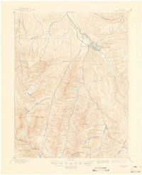
1895 Map of Aspen
USGS Topo · Published 1946About this map
Aspen is established at the confluence of the Roaring Fork and Hunter Creek during a period of intense silver extraction in the late nineteenth century. This 1893 survey details the industrial footprint of the district, showing the concentration of mineral works such as the Molly Gibson Mine and the Park Regent Mine flanking the town site, with the Holden Works situated to the west. The landscape is defined by deep glacial valleys and soaring peaks, including Maroon Peak and Castle Peak, which hem in the narrow corridors of commerce and transportation. The arrival of the Denver and Rio Grande R. R. (Aspen Br.) and the A. T. and S. F. R. R. (Colorado Midland Div.) illustrates the competition between rail lines to reach these high-altitude silver deposits. Further south, the map documents the smaller settlements of Highland and Ashcroft along Castle Creek, where the Montezuma Mine and Little Annie Mine highlight the reach of the mining boom into the surrounding White River National Forest.
Find a feature on this map
33 named features on this map. Tap any name to fly to it.
Don’t see what you’re looking for? This feature index may not catch every label — zoom into the map to look around manually.
Map Details
Editions of this 1895 Aspen Map
5 editions found
Other maps of this area

1888 · Crested Butte
USGS Topo · 1:62,500

1888 · Anthracite
USGS Topo · 1:62,500

1889 · Crested Butte
USGS Topo · 1:62,500

1889 · Anthracite
USGS Topo · 1:62,500

1893 · Anthracite
USGS Topo · 1:62,500

1893 · Crested Butte
USGS Topo · 1:62,500

1893 · Aspen
USGS Topo · 1:62,500

1894 · Anthracite
USGS Topo · 1:62,500

1895 · Aspen
USGS Topo · 1:62,500

1909 · Mount Jackson
USGS Topo · 1:125,000