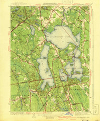
1941 Map of Assawompset Pond
USGS Topo · Published 1941About this map
Assawompset Pond and the surrounding lacustrine landscape of southeastern Massachusetts dominate this 1941 edition, illustrating a critical period for local water management and recreation. The map captures the complex system of interconnected basins, including Long Pond and Great Quittacas Pond, which served vital roles for urban utilities as evidenced by the Taunton Waterworks and New Bedford Waterworks. The surrounding terrain is a mosaic of family-named hills like Le Baron Hill and Aldens Hill, alongside specialized agriculture such as Bettys Neck Cranberry Bog and Fish Bogs. Small rural communities and summer settlements are shown at Nelsons Grove, Staples Shore, and Lakeside. Transportation is anchored by the New York New Haven and Hartford railroad, with the East Freetown Sta providing a crucial link to the region's interior. Numerous family burial grounds, including Haskins Cem and Strowbridge Cem, offer significant detail for genealogical research.
Find a feature on this map
125 named features on this map. Tap any name to fly to it.
Don’t see what you’re looking for? This feature index may not catch every label — zoom into the map to look around manually.
Map Details
Editions of this 1941 Assawompset Pond Map
3 editions found
Other maps of this area

1885 · New Bedford
USGS Topo · 1:62,500

1885 · Middleboro
USGS Topo · 1:62,500

1885 · Taunton
USGS Topo · 1:62,500

1888 · New Bedford
USGS Topo · 1:62,500

1888 · Fall River
USGS Topo · 1:62,500

1888 · Taunton
USGS Topo · 1:62,500

1888 · Middleboro
USGS Topo · 1:62,500

1893 · Taunton
USGS Topo · 1:62,500

1893 · Middleboro
USGS Topo · 1:62,500

1893 · Fall River
USGS Topo · 1:62,500