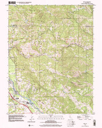
1998 Map of Asti
USGS Topo · Published 2002About this map
The Russian River defines the western valley floor in this late 20th-century survey, winding through the rich agricultural lands of the Alexander Valley and Musalacon. The small settlement of Asti serves as a focal point near the river, home to the Our Lady of Carmel Church and a modern Water Filtration Plant. To the east, the terrain rises sharply into the Mayacmas Mountains and Pine Mountain, a landscape marked by steep canyons such as Devils Den North and Big Sulphur Creek. The presence of the Cloverdale Municipal Airport and a Radio Repeater Station indicates the infrastructure supporting this portion of Sonoma County. Complex land divisions are evident through various Grant Boundary markings, illustrating the persistent influence of historical land grants on modern Californian geography.
Find a feature on this map
36 named features on this map. Tap any name to fly to it.
Don’t see what you’re looking for? This feature index may not catch every label — zoom into the map to look around manually.
Map Details
Editions of this 1998 Asti Map
This is the sole edition of this map. No revisions or reprints were ever made.
Other maps of this area

1920 · Healdsburg
USGS Topo · 1:62,500

1921 · Skaggs
USGS Topo · 1:62,500

1921 · Kelseyville
USGS Topo · 1:62,500

1933 · Healdsburg
USGS Topo · 1:48,000

1938 · Hopland
USGS Topo · 1:62,500

1940 · Healdsburg
USGS Topo · 1:62,500

1943 · Skaggs Springs
USGS Topo · 1:24,000

1943 · Kelseyville
USGS Topo · 1:62,500

1943 · Hopland
USGS Topo · 1:62,500

1944 · Skaggs Springs
USGS Topo · 1:31,680