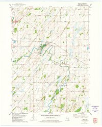
1980 Map of Astico
USGS Topo · Published 1981About this map
The Crawfish River winds through the heart of Dodge County, defining the rural character of the Astico and Danville areas. This 1980 survey reveals a landscape deeply connected to its agricultural roots, where family-named roads like Behan Road and Ninabuck Road segment the terrain between the river's meandering oxbows. The settlement at Astico is a focal point of activity, situated along the Chicago Milwaukee St Paul and Pacific rail line and adjacent to the Astico County Park, which includes a flowing well and campground.
Find a feature on this map
56 named features on this map. Tap any name to fly to it.
Don’t see what you’re looking for? This feature index may not catch every label — zoom into the map to look around manually.
Map Details
Editions of this 1980 Astico Map
This is the sole edition of this map. No revisions or reprints were ever made.
Other maps of this area

1890 · Sun Prairie
USGS Topo · 1:62,500

1891 · Waterloo
USGS Topo · 1:62,500

1894 · Waterloo
USGS Topo · 1:62,500

1896 · Sun Prairie
USGS Topo · 1:62,500

1905 · Sun Prairie
USGS Topo · 1:62,500

1907 · Sun Prairie
USGS Topo · 1:62,500

1910 · Waterloo
USGS Topo · 1:62,500

1955 · Columbus
USGS Topo · 1:62,500

1955 · Beaver Dam
USGS Topo · 1:62,500

1957 · Madison
USGS Topo · 1:250,000