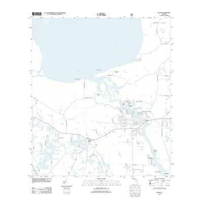
2012 Map of Astor
USGS Topo · Published 2012About this map
The Saint Johns River defines the landscape of this 2012 survey, winding northward between the settlements of Volusia and Astor. This region is a complex network of waterways, where the river meets the southern expanse of Lake George at the Volusia Bar. The community of Astor Park sits further west, anchored by the Astor Park Cem and Camp McQuarrie. Local commerce and recreation are centered around the water, evidenced by the Volusia Bar Fish Camp Marina and South Moon Fish Camp Marina. To the south, smaller riverfront settlements like Manhattan and Bluffton sit near the shores of Lake Dexter, while the Astor Lookout Tower stands as a notable landmark overlooking the surrounding terrain of Lungren Island and Falana Island.
Find a feature on this map
86 named features on this map. Tap any name to fly to it.
Don’t see what you’re looking for? This feature index may not catch every label — zoom into the map to look around manually.
Map Details
Editions of this 2012 Astor Map
This is the sole edition of this map. No revisions or reprints were ever made.
Other maps of this area

1954 · Daytona Beach
USGS Topo · 1:250,000

1958 · Daytona Beach
USGS Topo · 1:250,000

1962 · Lake Woodruff
USGS Topo · 1:24,000

1964 · Daytona Beach
USGS Topo · 1:250,000

1970 · Welaka SE
USGS Topo · 1:24,000

1970 · Seville
USGS Topo · 1:24,000

1970 · Salt Springs
USGS Topo · 1:24,000

1970 · Pierson
USGS Topo · 1:24,000

1972 · Juniper Springs
USGS Topo · 1:24,000
1972 · Farles Lake
USGS Topo · 1:24,000