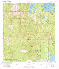
1972 Map of Farles Lake
USGS Topo · Published 1973About this map
Ocala National Forest defines this central Florida landscape, where the dense pine and scrub of the Big Scrub region meet a complex network of sinkholes and prairie lakes. During the early 1970s, the area supported both public recreation and military interests, evidenced by the U S Naval Reservation in the northern reaches and the Farles Prairie Recreation Area. The map reveals a land shaped by water and timber, with the Old Railroad Grade tracing former logging routes and the Pittman Work Center serving as a hub for forest management near Pittman. This survey provides a window into the varied use of the forest, from the quiet waters of Sellers Lake and Lake Dorr to the industrial mark of a Claypit and an Abandoned Airport near Camp Ocala.
Find a feature on this map
35 named features on this map. Tap any name to fly to it.
Don’t see what you’re looking for? This feature index may not catch every label — zoom into the map to look around manually.
Map Details
Editions of this 1972 Farles Lake Map
2 editions found
Other maps of this area

1954 · Daytona Beach
USGS Topo · 1:250,000

1955 · Orlando
USGS Topo · 1:250,000

1957 · Orlando
USGS Topo · 1:250,000

1958 · Orlando
USGS Topo · 1:250,000

1958 · Daytona Beach
USGS Topo · 1:250,000

1962 · Orlando
USGS Topo · 1:250,000

1964 · Daytona Beach
USGS Topo · 1:250,000

1965 · Umatilla
USGS Topo · 1:24,000
1965 · Paisley
USGS Topo · 1:24,000
1966 · Emeralda Island
USGS Topo · 1:24,000