1965 Map of Paisley
USGS Topo · Published 1967About this map
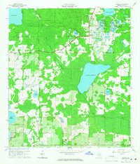
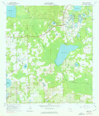
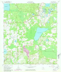
The Ocala National Forest dominates this mid-1960s landscape, where the dense Black Water Swamp and the waters of Lake Norris define the geography of northeast Lake County. The settlement of Paisley sits at the northern edge of this wilderness, marked by the Paisley Lookout Tower and nearby Johnsons Corner. The region is a dense network of water bodies, including the Chain O' Lakes and Lake Clearwater, many of which are situated along the Blue Lakes Ridge. Genealogists and local historians will find the Ponceannah Cem located centrally near the forest boundary, providing a vital link to the early families of this area. The map also captures the organized youth activity at Camp La-no-che on the shores of Lake Norris, alongside evidence of local industry such as a Sandpit and Gravel Pit.
Find a feature on this map
40 named features on this map. Tap any name to fly to it.
Don’t see what you’re looking for? This feature index may not catch every label — zoom into the map to look around manually.
Map Details
Editions of this 1965 Paisley Map
4 editions found

Other maps of this area

1954 · Daytona Beach
USGS Topo · 1:250,000

1955 · Orlando
USGS Topo · 1:250,000

1957 · Orlando
USGS Topo · 1:250,000

1958 · Orlando
USGS Topo · 1:250,000

1958 · Daytona Beach
USGS Topo · 1:250,000

1960 · Sorrento
USGS Topo · 1:24,000

1962 · Orlando
USGS Topo · 1:250,000

1962 · Pine Lakes
USGS Topo · 1:24,000

1962 · Lake Woodruff
USGS Topo · 1:24,000

1964 · Daytona Beach
USGS Topo · 1:250,000