
1965 Map of Paisley
USGS Topo · Published 1989About this map
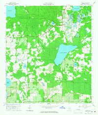
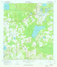
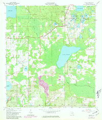
The Ocala National Forest dominates the landscape of this Lake County region, where the wooded terrain transitions into a complex network of wetlands and freshwater basins. The settlement of Paisley and nearby Johnsons Corner serve as the primary hubs of human activity, situated amidst a dense cluster of water bodies including the Chain O'Lakes and Blue Lakes Ridge. This area is characterized by the expansive Black Water Swamp and the meandering path of Black Water Creek, illustrating the natural drainage patterns that have historically shaped local development and land use in central Florida.
Find a feature on this map
40 named features on this map. Tap any name to fly to it.
Don’t see what you’re looking for? This feature index may not catch every label — zoom into the map to look around manually.
Map Details
Editions of this 1965 Paisley Map
4 editions found
Other maps of this area

1954 · Daytona Beach
USGS Topo · 1:250,000

1955 · Orlando
USGS Topo · 1:250,000

1957 · Orlando
USGS Topo · 1:250,000

1958 · Orlando
USGS Topo · 1:250,000

1958 · Daytona Beach
USGS Topo · 1:250,000

1960 · Sorrento
USGS Topo · 1:24,000

1962 · Orlando
USGS Topo · 1:250,000

1962 · Pine Lakes
USGS Topo · 1:24,000

1962 · Lake Woodruff
USGS Topo · 1:24,000

1964 · Daytona Beach
USGS Topo · 1:250,000