1965 Map of Paisley
USGS Topo · Published 1976About this map
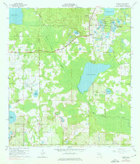
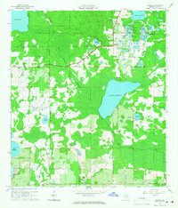
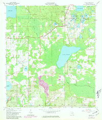
Paisley serves as the central settlement in this mid-1960s survey of Lake County, where the dense woodlands of the Ocala National Forest meet an intricate network of freshwater lakes. The landscape is defined by its diverse hydrology, from the large expanse of Lake Norris and Lake Dorr to the smaller pools of the Chain O'Lakes. A notable cultural landmark is Camp La-no-che, situated on the northern shore of Lake Norris, while the Ponceannah Cem and Johnsons Corner offer specific points of interest for genealogists tracing local families. The presence of the Paisley Lookout Tower and scattered resource sites like the Sandpit and Gravel Pit suggest a rural economy tied to both forest management and land extraction. To the south and east, the Black Water Swamp and Black Water Creek illustrate the low-lying, poorly drained terrain that dictated early settlement patterns and road placements like De Land Road.
Find a feature on this map
42 named features on this map. Tap any name to fly to it.
Don’t see what you’re looking for? This feature index may not catch every label — zoom into the map to look around manually.
Map Details
Editions of this 1965 Paisley Map
4 editions found

Other maps of this area

1954 · Daytona Beach
USGS Topo · 1:250,000

1955 · Orlando
USGS Topo · 1:250,000

1957 · Orlando
USGS Topo · 1:250,000

1958 · Orlando
USGS Topo · 1:250,000

1958 · Daytona Beach
USGS Topo · 1:250,000

1960 · Sorrento
USGS Topo · 1:24,000

1962 · Orlando
USGS Topo · 1:250,000

1962 · Pine Lakes
USGS Topo · 1:24,000

1962 · Lake Woodruff
USGS Topo · 1:24,000

1964 · Daytona Beach
USGS Topo · 1:250,000