1965 Map of Paisley
USGS Topo · Published 1981About this map
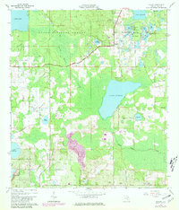
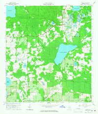
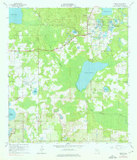
Paisley and the rural intersection at Johnsons Corner anchor this landscape of the eastern Ocala National Forest in the mid-1960s. The map reveals a dense network of water bodies, from the large expanse of Lake Norris and Lake Dorr to smaller basins like Lake Clearwater and the Chain O'Lakes. These waters are linked by the winding Black Water Creek and the vast Black Water Swamp, illustrating the hydrologic complexity of Lake County before extensive modern development.
Find a feature on this map
37 named features on this map. Tap any name to fly to it.
Don’t see what you’re looking for? This feature index may not catch every label — zoom into the map to look around manually.
Map Details
Editions of this 1965 Paisley Map
4 editions found

Other maps of this area

1954 · Daytona Beach
USGS Topo · 1:250,000

1955 · Orlando
USGS Topo · 1:250,000

1957 · Orlando
USGS Topo · 1:250,000

1958 · Orlando
USGS Topo · 1:250,000

1958 · Daytona Beach
USGS Topo · 1:250,000

1960 · Sorrento
USGS Topo · 1:24,000

1962 · Orlando
USGS Topo · 1:250,000

1962 · Pine Lakes
USGS Topo · 1:24,000

1962 · Lake Woodruff
USGS Topo · 1:24,000

1964 · Daytona Beach
USGS Topo · 1:250,000