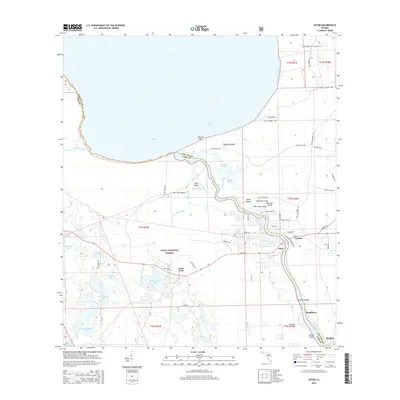
2015 Map of Astor
USGS Topo · Published 2015About this map
The Saint Johns River carves a winding path through this landscape, serving as a vital waterway near the transition into the southern reaches of Lake George. This 2015 survey reveals the established settlements of Astor and Astor Park, where residential development is concentrated along the riverbanks and the corridor of SR-40. To the west, the protected wilderness of the Ocala National Forest dominates the terrain, dotted with numerous water bodies such as Schimmerhorn Lake and Wildcat Lake. The map preserves the locations of several smaller settlements and landings, including Manhatten and Bluffton, alongside local landmarks like Morrison Bluff and the Astor Park Cem. This riverine environment, marked by features like the Volusia Bar and Blue Creek Island, illustrates the enduring relationship between the community and the complex network of creeks and marshes that define the region's geography.
Find a feature on this map
70 named features on this map. Tap any name to fly to it.
Don’t see what you’re looking for? This feature index may not catch every label — zoom into the map to look around manually.
Map Details
Editions of this 2015 Astor Map
This is the sole edition of this map. No revisions or reprints were ever made.
Other maps of this area

1954 · Daytona Beach
USGS Topo · 1:250,000

1958 · Daytona Beach
USGS Topo · 1:250,000

1962 · Lake Woodruff
USGS Topo · 1:24,000

1964 · Daytona Beach
USGS Topo · 1:250,000

1970 · Welaka SE
USGS Topo · 1:24,000

1970 · Seville
USGS Topo · 1:24,000

1970 · Salt Springs
USGS Topo · 1:24,000

1970 · Pierson
USGS Topo · 1:24,000

1972 · Juniper Springs
USGS Topo · 1:24,000
1972 · Farles Lake
USGS Topo · 1:24,000