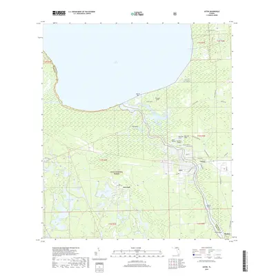
2018 Map of Astor
USGS Topo · Published 2018About this map
Astor and Astor Park anchor this riverfront landscape where the Saint Johns River flows north into the southern reaches of Lake George. The area is characterized by a complex network of wetlands and waterways, including Hitchens Creek, Blue Creek, and Jumping Gully, which thread through the eastern edge of the Ocala National Forest. The settlement patterns here are deeply tied to the water, with the community of Volusia positioned near the riverbank and the isolated settlement of Bluffton further south. Local history is evidenced by the Astor Park Cem and several named islands and high points such as Shell Mound, Morrison Island, and Hitchens Island. The transition from forest to marsh is marked by numerous small lakes, including Schimmerhorn Lake and the Grasshopper Lakes, reflecting the low-lying geography of the Lake and Volusia County border.
Find a feature on this map
58 named features on this map. Tap any name to fly to it.
Don’t see what you’re looking for? This feature index may not catch every label — zoom into the map to look around manually.
Map Details
Editions of this 2018 Astor Map
This is the sole edition of this map. No revisions or reprints were ever made.
Other maps of this area

1954 · Daytona Beach
USGS Topo · 1:250,000

1958 · Daytona Beach
USGS Topo · 1:250,000

1962 · Lake Woodruff
USGS Topo · 1:24,000

1964 · Daytona Beach
USGS Topo · 1:250,000

1970 · Welaka SE
USGS Topo · 1:24,000

1970 · Seville
USGS Topo · 1:24,000

1970 · Salt Springs
USGS Topo · 1:24,000

1970 · Pierson
USGS Topo · 1:24,000

1972 · Juniper Springs
USGS Topo · 1:24,000
1972 · Farles Lake
USGS Topo · 1:24,000