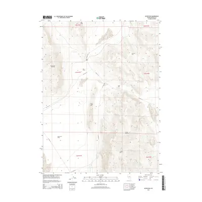
2014 Map of Astor Pass
USGS Topo · Published 2014About this map
Astor Pass and Sand Pass serve as the primary topographic focal points in this arid corner of Washoe County. The landscape is defined by the convergence of several high-desert landforms, including the Sand Range, Smoke Creek Mountains, and the Virginia Mountains. A network of unpaved desert routes, such as Surprise Valley Rd and Fish Springs Rd, trace the low ground between the Never Sweat Hills and Terraced Hills, hinting at the traditional movement of people and livestock through this high basin. Significant for local hydrology and historical survival in this environment are the dispersed water sources, including Mocho Spring Number Two, Upper Adobe Spring, and Lower Adobe Spring. The map also details the northeastern edge of Honey Lake Valley, illustrating a complex terrain of basins and ridges that has long shaped navigation in the western Great Basin.
Find a feature on this map
25 named features on this map. Tap any name to fly to it.
Don’t see what you’re looking for? This feature index may not catch every label — zoom into the map to look around manually.
Map Details
Editions of this 2014 Astor Pass Map
This is the sole edition of this map. No revisions or reprints were ever made.
Other maps of this area

1886 · Granite Range
USGS Topo · 1:250,000

1894 · Granite Range
USGS Topo · 1:250,000

1955 · Lovelock
USGS Topo · 1:250,000

1959 · Lovelock
USGS Topo · 1:250,000

1964 · The Needle Rocks
USGS Topo · 1:24,000
1964 · Pyramid SW
USGS Topo · 1:24,000
1964 · State Line Peak
USGS Topo · 1:24,000
1964 · Astor Pass
USGS Topo · 1:24,000
1964 · Flanigan
USGS Topo · 1:24,000
1964 · Spanish Flat
USGS Topo · 1:24,000