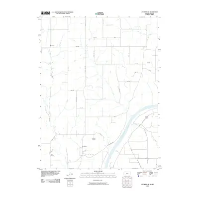
2009 Map of Atchison NE
USGS Topo · Published 2009About this map
Doniphan and Brenner anchor the uplands of northeast Kansas in this 2009 survey, where the landscape is defined by the sharp transition from agricultural plateaus to the wide valley of the Missouri River. The area is carved by a dense network of drainages including Cottonwood Creek, Rock Creek, and Larkinburg Creek, which feed the river bottomlands. This map reveals a strictly gridded rural road system with names reflecting local landmarks and family histories, such as Minerial Point Rd, Lone Star Rd, and Last Chance Rd. Local genealogists will find value in the distinct placements of Doniphan Cemetery, Rosendale Cemetery, and Myers Cemetery. Near the riverbank, the presence of the Booze Island Airport suggests the specialized utility of the floodplain even as traditional settlements like Doniphan maintain their historic footprint away from the water's edge.
Find a feature on this map
45 named features on this map. Tap any name to fly to it.
Don’t see what you’re looking for? This feature index may not catch every label — zoom into the map to look around manually.
Map Details
Editions of this 2009 Atchison NE Map
This is the sole edition of this map. No revisions or reprints were ever made.
Other maps of this area

1885 · Atchison
USGS Topo · 1:125,000

1888 · Atchison
USGS Topo · 1:125,000

1893 · Atchison
USGS Topo · 1:125,000

1924 · St. Joseph
USGS Topo · 1:62,500

1926 · Atchison
USGS Topo · 1:62,500

1926 · Saint Joseph
USGS Topo · 1:62,500

1926 · Oregon
USGS Topo · 1:62,500

1927 · Dearborn
USGS Topo · 1:62,500

1950 · Kansas City
USGS Topo · 1:250,000
1951 · De Kalb
USGS Topo · 1:24,000