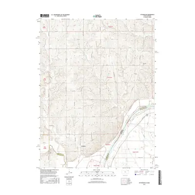
2016 Map of Atchison NE
USGS Topo · Published 2016About this map
The Missouri River forms a dynamic boundary in this 2016 survey, separating Doniphan County, Kansas, from Buchanan County, Missouri. The settlement of Doniphan sits perched above the floodplain, near the Doniphan Cem and the winding course of Independence Creek. The landscape is defined by a dense network of upland drainage, including Rock Creek, Cottonwood Creek, and Brush Creek, which carve deep valleys into the loess bluffs before reaching the wide river bottom. On the Missouri side, the Hall Levee protects the low-lying agricultural lands, where Booze Island Airport serves as a small aviation landmark. For genealogists and local historians, several family and community landmarks are visible, such as Rosendale Cem and Myers Cem, alongside rural thoroughfares like Mineral Point Rd and Last Chance Rd.
Find a feature on this map
47 named features on this map. Tap any name to fly to it.
Don’t see what you’re looking for? This feature index may not catch every label — zoom into the map to look around manually.
Map Details
Editions of this 2016 Atchison NE Map
This is the sole edition of this map. No revisions or reprints were ever made.
Other maps of this area

1885 · Atchison
USGS Topo · 1:125,000

1888 · Atchison
USGS Topo · 1:125,000

1893 · Atchison
USGS Topo · 1:125,000

1924 · St. Joseph
USGS Topo · 1:62,500

1926 · Atchison
USGS Topo · 1:62,500

1926 · Saint Joseph
USGS Topo · 1:62,500

1926 · Oregon
USGS Topo · 1:62,500

1927 · Dearborn
USGS Topo · 1:62,500

1950 · Kansas City
USGS Topo · 1:250,000
1951 · De Kalb
USGS Topo · 1:24,000