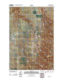
2011 Map of Athena
USGS Topo · Published 2011About this map
Athena and Weston serve as the primary hubs in this part of Umatilla County, where the agricultural plains meet the rising slopes of Blue Mountain. The landscape is defined by a dense network of country roads such as Wild Horse Rd and La Mar Gulch Rd, connecting isolated farmsteads and small settlements like Downing. Water management is central to the area's geography, with Wildhorse Creek, Pine Creek, and Hay Creek carving drainage patterns across the terrain toward the Poplar Springs Reservoir. Genealogists will find significant value in the detailed placement of the Weston Cemetery and Key Cemetery, as well as the identification of civic landmarks including the Athena Post Office and Barrett Field. The transition from the flatlands around Spring Hollow Creek to the more varied topography of La Marr Gulch and Eagle Creek illustrates the environmental shift occurring at the edge of the mountains.
Find a feature on this map
43 named features on this map. Tap any name to fly to it.
Don’t see what you’re looking for? This feature index may not catch every label — zoom into the map to look around manually.
Map Details
Editions of this 2011 Athena Map
This is the sole edition of this map. No revisions or reprints were ever made.
Other maps of this area

1935 · Pendleton
USGS Topo · 1:125,000

1953 · Pendleton
USGS Topo · 1:250,000

1956 · Pendleton
USGS Topo · 1:250,000

1964 · Milton-Freewater
USGS Topo · 1:24,000

1964 · Thorn Hollow
USGS Topo · 1:24,000

1964 · Athena
USGS Topo · 1:24,000

1964 · Bowlus Hill
USGS Topo · 1:24,000

1964 · Weston Mountain
USGS Topo · 1:24,000

1964 · Gibbon
USGS Topo · 1:24,000
1966 · Adams
USGS Topo · 1:24,000