
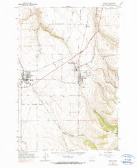
1964 Map of Athena
USGS Topo · Published 1965About this map
The agricultural landscape of Umatilla County in the mid-1960s is defined by the intersection of rail lines and tribal history. Athena and Weston stand as the primary population centers, connected by the Northern Pacific railroad and surrounded by a network of drainage ways like Wildhorse Creek and Pine Creek. A significant portion of the southern area lies within the Umatilla Indian Reservation Boundary, with the Old Indian Treaty Boundary cutting across the western quadrant. Locally important institutions are documented, including McEwen High Sch and multiple burial grounds such as Weston Cemetery and Key Cemetery. The map also captures the industrial infrastructure of the era, noting a Cannery at Weston Station and numerous gravel pits, indicating the area's reliance on processing and material extraction near the foothills of the Blue Mountains.
Find a feature on this map
40 named features on this map. Tap any name to fly to it.
Don’t see what you’re looking for? This feature index may not catch every label — zoom into the map to look around manually.
Map Details
Editions of this 1964 Athena Map
2 editions found
Other maps of this area

1935 · Pendleton
USGS Topo · 1:125,000

1953 · Pendleton
USGS Topo · 1:250,000

1956 · Pendleton
USGS Topo · 1:250,000

1964 · Milton-Freewater
USGS Topo · 1:24,000

1964 · Thorn Hollow
USGS Topo · 1:24,000

1964 · Bowlus Hill
USGS Topo · 1:24,000

1964 · Weston Mountain
USGS Topo · 1:24,000

1964 · Gibbon
USGS Topo · 1:24,000
1966 · Adams
USGS Topo · 1:24,000
1966 · Cayuse
USGS Topo · 1:24,000