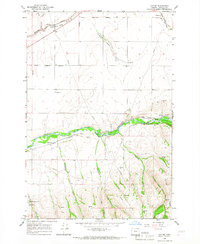
1966 Map of Cayuse
USGS Topo · Published 1967About this map
The Umatilla River valley serves as the central corridor for transport and settlement in this mid-1960s Oregon landscape. The Union Pacific railroad tracks parallel the river, connecting small station points and community centers like Cayuse, Minthorn, and Homly. Agriculture and early industrial history are evident through the presence of a Grain Elevator at Blakeley and the historical Grist Mill (Site) near the riverbank.
Find a feature on this map
35 named features on this map. Tap any name to fly to it.
Don’t see what you’re looking for? This feature index may not catch every label — zoom into the map to look around manually.
Map Details
Editions of this 1966 Cayuse Map
This is the sole edition of this map. No revisions or reprints were ever made.
Other maps of this area

1935 · Pendleton
USGS Topo · 1:125,000

1953 · Pendleton
USGS Topo · 1:250,000

1956 · Pendleton
USGS Topo · 1:250,000

1964 · Thorn Hollow
USGS Topo · 1:24,000

1964 · Athena
USGS Topo · 1:24,000

1964 · Meacham
USGS Topo · 1:24,000

1966 · Cabbage Hill
USGS Topo · 1:24,000
1966 · Adams
USGS Topo · 1:24,000

1966 · Table Rock
USGS Topo · 1:24,000

1966 · Mission
USGS Topo · 1:24,000