
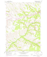
1966 Map of Cabbage Hill
USGS Topo · Published 1967About this map
Umatilla Indian Reservation Bdy land dominates this 1960s study of the steep ascent east of Pendleton. The terrain is characterized by the dramatic rise of Cabbage Hill and Emigrant Hill, where the modern highway corridor snakes through the landscape near Deadman Pass. The presence of the Cabbage Hill Sch and a remote Landing Strip suggests the localized infrastructure serving this high-elevation plateau during the mid-century. The map meticulously details a network of water sources essential to the region, from the headwaters of Mission Creek to the deep incisions of Doe Canyon and North Fork McKay Creek. Several Radio Towers and a prominent lookout at Boiling Point underscore the importance of this ridge for regional communications and navigation across the Table Land and Kanine Ridge.
Find a feature on this map
30 named features on this map. Tap any name to fly to it.
Don’t see what you’re looking for? This feature index may not catch every label — zoom into the map to look around manually.
Map Details
Editions of this 1966 Cabbage Hill Map
2 editions found
Other maps of this area

1935 · Pendleton
USGS Topo · 1:125,000

1953 · Pendleton
USGS Topo · 1:250,000

1956 · Pendleton
USGS Topo · 1:250,000

1963 · Meacham Lake
USGS Topo · 1:24,000

1964 · Thorn Hollow
USGS Topo · 1:24,000

1964 · Meacham
USGS Topo · 1:24,000
1966 · Cayuse
USGS Topo · 1:24,000

1966 · Table Rock
USGS Topo · 1:24,000

1966 · Mission
USGS Topo · 1:24,000
1967 · Bassey Creek
USGS Topo · 1:24,000