
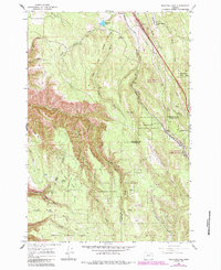
1963 Map of Meacham Lake
USGS Topo · Published 1965About this map
Meacham and Kamela anchor this high-elevation study of the Blue Mountains, showing the complex interaction between timber land, transportation, and federal oversight in the early 1960s. The Union Pacific Railroad winds through the canyons alongside the Umatilla National Forest, following the steep grades of the Blue Mountain crossing. This survey documents significant infrastructure of the era, including a U S Weather Bureau Station, an Airway Beacon, and the Tip Top Lookout Tower, highlighting the area's role in regional monitoring and aviation safety. The landscape is also marked by deeper histories, such as the Old Indian Treaty Boundary and isolated markers like a Grave near Beaver Creek, providing specific touchpoints for local historians and genealogists tracing early settlement patterns in the Umatilla and Union County borderlands.
Find a feature on this map
39 named features on this map. Tap any name to fly to it.
Don’t see what you’re looking for? This feature index may not catch every label — zoom into the map to look around manually.
Map Details
Editions of this 1963 Meacham Lake Map
2 editions found
Other maps of this area

1935 · Pendleton
USGS Topo · 1:125,000

1953 · Pendleton
USGS Topo · 1:250,000

1956 · Pendleton
USGS Topo · 1:250,000

1964 · Mc Intyre Creek
USGS Topo · 1:24,000

1964 · Duncan
USGS Topo · 1:24,000

1964 · Huron
USGS Topo · 1:24,000

1964 · Meacham
USGS Topo · 1:24,000

1964 · Kamela SE
USGS Topo · 1:24,000

1966 · Cabbage Hill
USGS Topo · 1:24,000
1967 · Bassey Creek
USGS Topo · 1:24,000