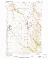
1964 Map of Athena
USGS Topo · Published 1990About this map
The agricultural hub of Athena and its neighboring settlement Weston are the focal points of this mid-century Umatilla County landscape. The map illustrates a region defined by the intersection of early transportation and shifting territorial lines, most notably where the Old Indian Treaty Boundary and the Umatilla Indian Reservation Boundary intersect the lowlands. The local economy is visibly anchored by the Pacific Highway and competing rail lines, including the Northern Pacific and Union Pacific.
Find a feature on this map
34 named features on this map. Tap any name to fly to it.
Don’t see what you’re looking for? This feature index may not catch every label — zoom into the map to look around manually.
Map Details
Editions of this 1964 Athena Map
2 editions found
Other maps of this area

1935 · Pendleton
USGS Topo · 1:125,000

1953 · Pendleton
USGS Topo · 1:250,000

1956 · Pendleton
USGS Topo · 1:250,000

1964 · Milton-Freewater
USGS Topo · 1:24,000

1964 · Thorn Hollow
USGS Topo · 1:24,000

1964 · Athena
USGS Topo · 1:24,000

1964 · Bowlus Hill
USGS Topo · 1:24,000

1964 · Weston Mountain
USGS Topo · 1:24,000

1964 · Gibbon
USGS Topo · 1:24,000
1966 · Adams
USGS Topo · 1:24,000