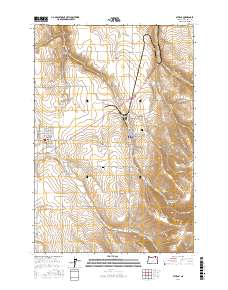
2017 Map of Athena
USGS Topo · Published 2017About this map
Athena and Weston serve as the primary hubs of this Umatilla County landscape, where the flatlands of the Walla Walla Valley meet the rising slopes of Weston Mountain. The map shows a transition from structured town grids to the drainage networks of Wildhorse Creek and Pine Creek. Local history is anchored by the Weston Cemetery and Kee Cemetery, while the surrounding terrain is marked by family-named landmarks like Reed and Hawley Mountain. Agricultural and water infrastructure is evident through features such as Poplar Springs Reservoir and various named canyons including Dry Hollow and La Marr Gulch. The road network connects these settlements via historical routes like Main Street and Banister Road, illustrating the ongoing development of this region's rural and small-town character.
Find a feature on this map
63 named features on this map. Tap any name to fly to it.
Don’t see what you’re looking for? This feature index may not catch every label — zoom into the map to look around manually.
Map Details
Editions of this 2017 Athena Map
This is the sole edition of this map. No revisions or reprints were ever made.
Other maps of this area

1935 · Pendleton
USGS Topo · 1:125,000

1953 · Pendleton
USGS Topo · 1:250,000

1956 · Pendleton
USGS Topo · 1:250,000

1964 · Milton-Freewater
USGS Topo · 1:24,000

1964 · Thorn Hollow
USGS Topo · 1:24,000

1964 · Athena
USGS Topo · 1:24,000

1964 · Bowlus Hill
USGS Topo · 1:24,000

1964 · Weston Mountain
USGS Topo · 1:24,000

1964 · Gibbon
USGS Topo · 1:24,000
1966 · Adams
USGS Topo · 1:24,000