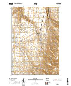
2020 Map of Athena
USGS Topo · Published 2020About this map
The agricultural plains of Umatilla County meet the rising elevations of the Blue Mountain foothills in this detailed survey of Athena and Weston. The landscape is defined by the drainage patterns of Wildhorse Cr and Pine Cr, which cut through the undulating wheat country. In the eastern portion of the map, the terrain rises sharply toward Weston Mtn and Reed and Hawley Mtn, where numerous natural water sources like Green Spring and Earthquake Spring are documented. For those tracing local history, the map provides clear placement for the Weston Cem and Key Cem, as well as the intricate street grids of the two primary settlements. The presence of Poplar Springs Reservoir highlights the managed water resources essential to this high-prairie environment, while smaller features like Dry Hollow and La Marr Gulch reveal the localized topography between the creek beds.
Find a feature on this map
67 named features on this map. Tap any name to fly to it.
Don’t see what you’re looking for? This feature index may not catch every label — zoom into the map to look around manually.
Map Details
Editions of this 2020 Athena Map
This is the sole edition of this map. No revisions or reprints were ever made.
Other maps of this area

1935 · Pendleton
USGS Topo · 1:125,000

1953 · Pendleton
USGS Topo · 1:250,000

1956 · Pendleton
USGS Topo · 1:250,000

1964 · Milton-Freewater
USGS Topo · 1:24,000

1964 · Thorn Hollow
USGS Topo · 1:24,000

1964 · Athena
USGS Topo · 1:24,000

1964 · Bowlus Hill
USGS Topo · 1:24,000

1964 · Weston Mountain
USGS Topo · 1:24,000

1964 · Gibbon
USGS Topo · 1:24,000
1966 · Adams
USGS Topo · 1:24,000