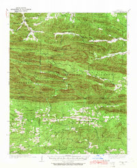
1936 Map of Athens
USGS Topo · Published 1966About this map
Athens and the surrounding Ouachita highlands of Montgomery, Polk, and Howard Counties appear here as they were during the mid-1930s. The landscape is defined by the sharp east-west ridges of the Missouri Mountains and Gap Springs Mountain, which channel the headwaters of the Little Missouri River and the Caddo River. This era is marked by New Deal-era infrastructure, including a CCC Camp at Cox Spring and several fire towers, such as the one atop Little Missouri Mountain.
Find a feature on this map
88 named features on this map. Tap any name to fly to it.
Don’t see what you’re looking for? This feature index may not catch every label — zoom into the map to look around manually.
Map Details
Editions of this 1936 Athens Map
4 editions found
Other maps of this area

1890 · Mount Ida
USGS Topo · 1:125,000

1890 · Poteau Mountain
USGS Topo · 1:125,000

1899 · Poteau Mountain
USGS Topo · 1:125,000

1906 · Caddo Gap
USGS Topo · 1:125,000

1913 · De Queen
USGS Topo · 1:125,000

1936 · Athens
USGS Topo · 1:48,000

1936 · Glenwood
USGS Topo · 1:48,000

1942 · Glenwood
USGS Topo · 1:62,500

1942 · Athens
USGS Topo · 1:62,500

1949 · Glenwood
USGS Topo · 1:62,500