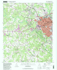
1998 Map of Athens West
USGS Topo · Published 1999About this map
The western periphery of Athens is defined by the winding course of the Middle Oconee River and McNutt Creek, where institutional and agricultural lands meet urban expansion at the close of the 20th century. The map highlights the US Naval Supply Corps School and the extensive US Dept of Agriculture Experimental Station, alongside established local landmarks like the Athens Speedway and Evergreen Memorial Park. For genealogists, the rural areas south and west of the city center are dotted with family-named landmarks and country churches, including Robinson Cem, Edwards Chapel, and Boggs Chapel. The transition from the dense street grids around Prince Ave Baptist Ch to the outlying settlements of Oconee Heights and Eastville illustrates the region's late-century suburbanization. Educational and industrial history is represented by the High and Industrial Sch and the Univ of Georgia (Whitehall Farm) at the southern edge of the quadrangle.
Find a feature on this map
96 named features on this map. Tap any name to fly to it.
Don’t see what you’re looking for? This feature index may not catch every label — zoom into the map to look around manually.
Map Details
Editions of this 1998 Athens West Map
This is the sole edition of this map. No revisions or reprints were ever made.
Other maps of this area

1891 · Gainesville
USGS Topo · 1:125,000

1891 · Carnesville
USGS Topo · 1:125,000

1896 · Monroe
USGS Topo · 1:125,000

1953 · Athens
USGS Topo · 1:250,000

1954 · Greenville
USGS Topo · 1:250,000

1958 · Greenville
USGS Topo · 1:250,000

1958 · Athens
USGS Topo · 1:250,000

1959 · Athens
USGS Topo · 1:250,000

1963 · Athens
USGS Topo · 1:250,000

1964 · Athens West
USGS Topo · 1:24,000