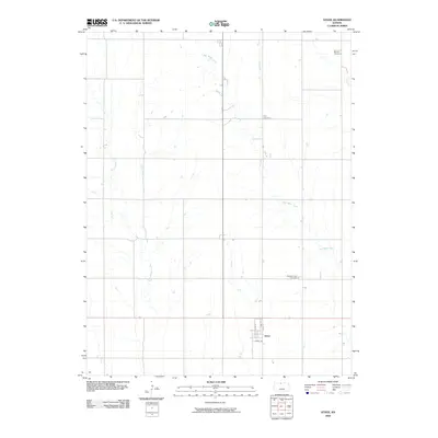
2009 Map of Athol
USGS Topo · Published 2009About this map
Athol anchors the southern portion of this northern Kansas landscape, revealing a structured small-town grid defined by Main St, Pine St, and Cedar St. The surrounding Smith County countryside is a study in rural organization, where the section-line roads carve through a watershed dominated by West Beaver Creek and East Cedar Creek. The presence of multiple burial grounds, including Meade Cemetery in the northeast and the Pleasant View Cemetery further south, provides essential markers for genealogical research in this agricultural region. Smaller tributaries like Cottonwood Creek and N Beaver Cr dictate the roll of the land, while the layout of Dyers St shows the community's local development pattern at this time.
Find a feature on this map
12 named features on this map. Tap any name to fly to it.
Don’t see what you’re looking for? This feature index may not catch every label — zoom into the map to look around manually.
Map Details
Editions of this 2009 Athol Map
This is the sole edition of this map. No revisions or reprints were ever made.
Other maps of this area

1893 · Smith Center
USGS Topo · 1:125,000

1893 · Phillipsburg
USGS Topo · 1:125,000

1955 · Beloit
USGS Topo · 1:250,000

1959 · Beloit
USGS Topo · 1:250,000

1972 · Kirwin
USGS Topo · 1:24,000

1973 · Kensington
USGS Topo · 1:24,000

1973 · Athol
USGS Topo · 1:24,000

1973 · Kensington NE
USGS Topo · 1:24,000
1973 · Reamsville
USGS Topo · 1:24,000
1973 · Cedar
USGS Topo · 1:24,000