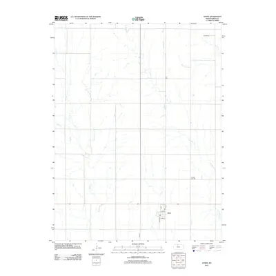
2012 Map of Athol
USGS Topo · Published 2012About this map
Athol anchors the southern portion of this north-central Kansas landscape, situated near the intersection of several local thoroughfares including Chicago and Main streets. The layout of the town is remarkably compact, giving way quickly to the expansive agricultural grid of Smith County. This map documents a series of critical rural landmarks that are vital for genealogical research, such as Pleasant View Cem, Zion Cem, and Meade Cem. These sites are distributed across a terrain defined by the drainage patterns of W Beaver Cr, Cottonwood Cr, and E Cedar Cr. The road network, including Co Rd 515, follows the section lines of the Public Land Survey System, illustrating how human settlement and transit have been dictated by the geometry of the Great Plains.
Find a feature on this map
14 named features on this map. Tap any name to fly to it.
Don’t see what you’re looking for? This feature index may not catch every label — zoom into the map to look around manually.
Map Details
Editions of this 2012 Athol Map
This is the sole edition of this map. No revisions or reprints were ever made.
Other maps of this area

1893 · Smith Center
USGS Topo · 1:125,000

1893 · Phillipsburg
USGS Topo · 1:125,000

1955 · Beloit
USGS Topo · 1:250,000

1959 · Beloit
USGS Topo · 1:250,000

1972 · Kirwin
USGS Topo · 1:24,000

1973 · Kensington
USGS Topo · 1:24,000

1973 · Athol
USGS Topo · 1:24,000

1973 · Kensington NE
USGS Topo · 1:24,000
1973 · Reamsville
USGS Topo · 1:24,000
1973 · Cedar
USGS Topo · 1:24,000