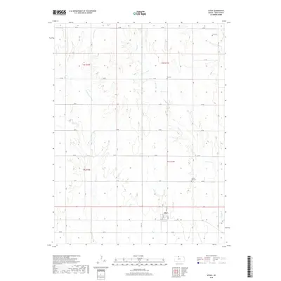
2018 Map of Athol
USGS Topo · Published 2018About this map
The settlement of Athol serves as the primary hub on this North Central Kansas landscape, where the grid of Main St, Cedar St, and Pine St provides a structured core amidst the surrounding agricultural expanses of Smith County. The terrain is defined by several watercourses including Cottonwood Cr, W Beaver Cr, and E Cedar Cr, which cut through the township divisions of t2s r15w, t2s r14w, t3s r15w, and t3s r14w. Local history and genealogy researchers will find several well-defined burial grounds across the area, including Meade Cem, Zion Cem, and Pleasant View Cem, each positioned near the local road network of numbered and lettered routes like Co Rd 515 and F Rd. The map illustrates a meticulously planned section-line road system that organizes the rural landscape into predictable parcels characteristic of the Great Plains.
Find a feature on this map
29 named features on this map. Tap any name to fly to it.
Don’t see what you’re looking for? This feature index may not catch every label — zoom into the map to look around manually.
Map Details
Editions of this 2018 Athol Map
This is the sole edition of this map. No revisions or reprints were ever made.
Other maps of this area

1893 · Smith Center
USGS Topo · 1:125,000

1893 · Phillipsburg
USGS Topo · 1:125,000

1955 · Beloit
USGS Topo · 1:250,000

1959 · Beloit
USGS Topo · 1:250,000

1972 · Kirwin
USGS Topo · 1:24,000

1973 · Kensington
USGS Topo · 1:24,000

1973 · Athol
USGS Topo · 1:24,000

1973 · Kensington NE
USGS Topo · 1:24,000
1973 · Reamsville
USGS Topo · 1:24,000
1973 · Cedar
USGS Topo · 1:24,000