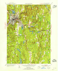
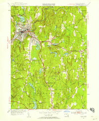
1954 Map of Athol
USGS Topo · Published 1956About this map
The Millers River corridor serves as the industrial and civic anchor for this mid-century portrait of Worcester County, where the growing hub of Athol transitions into the managed woodlands of the Harvard Forest. The river's path is closely shadowed by the Boston and Maine Railroad, illustrating the vital rail-to-river connection that fueled local enterprise, including the Phillipston Mill. Beyond the urban density of East Athol, the landscape is defined by an intricate network of water management, featuring the Bates Power Reservoir and Thousand Acre Reservoir.
Find a feature on this map
66 named features on this map. Tap any name to fly to it.
Don’t see what you’re looking for? This feature index may not catch every label — zoom into the map to look around manually.
Map Details
Editions of this 1954 Athol Map
3 editions found

Other maps of this area

1887 · Warwick
USGS Topo · 1:62,500

1887 · Belchertown
USGS Topo · 1:62,500

1887 · Winchendon
USGS Topo · 1:62,500

1887 · Barre
USGS Topo · 1:62,500

1889 · Barre
USGS Topo · 1:62,500

1889 · Warwick
USGS Topo · 1:62,500

1890 · Belchertown
USGS Topo · 1:62,500

1890 · Winchendon
USGS Topo · 1:62,500

1893 · Belchertown
USGS Topo · 1:62,500

1894 · Winchendon
USGS Topo · 1:62,500