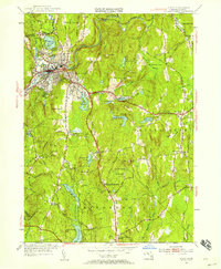
1954 Map of Athol
USGS Topo · Published 1958About this map
Athol stands as a primary hub along the Millers River in this mid-century topographic survey, showing a landscape defined by industrial development and extensive forestry research. The northern corridors follow the Boston and Maine RR and the Mohawk Trail, which bridge the gap between the settled mill town and the surrounding hill country. To the south and east, the map reveals the institutional footprint of the Harvard Forest, including the Administration Bldg Harvard Forest, alongside the protected reaches of Petersham State Forest. Local genealogy is well-preserved through numerous rural burial grounds like Fay Cem and New Sherborn Cem, while small settlements such as Phillipston and Phillipston Four Corners remain centered around landmarks like the Phillipston No 1 Sch. The terrain is punctuated by significant water management features, including the Thousand Acre Reservoir and Riceville Pond, serving both industrial and residential needs.
Find a feature on this map
51 named features on this map. Tap any name to fly to it.
Don’t see what you’re looking for? This feature index may not catch every label — zoom into the map to look around manually.
Map Details
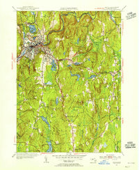
Editions of this 1954 Athol Map
3 editions found

Other maps of this area

1887 · Warwick
USGS Topo · 1:62,500

1887 · Belchertown
USGS Topo · 1:62,500

1887 · Winchendon
USGS Topo · 1:62,500

1887 · Barre
USGS Topo · 1:62,500

1889 · Barre
USGS Topo · 1:62,500

1889 · Warwick
USGS Topo · 1:62,500

1890 · Belchertown
USGS Topo · 1:62,500

1890 · Winchendon
USGS Topo · 1:62,500

1893 · Belchertown
USGS Topo · 1:62,500

1894 · Winchendon
USGS Topo · 1:62,500