
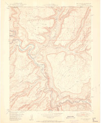
1949 Map of Atkinson Creek
USGS Topo · Published 1955About this map
Wright Mines and the edge of the Uncompahgre National Forest define this landscape along the Mesa and Montrose County line. Produced in cooperation with the United States Atomic Energy Commission, the map details the complex drainage systems of Atkinson Creek and its tributaries, including West Atkinson Creek and Big Atkinson Creek. The topography is marked by significant elevation changes across Atkinson Breaks and Little Atkinson Mesa, dropping toward the San Miguel River in the southwest corner. Local movement at this time was supported by a Truck Trail winding through Hog Park and Hog Wash. The settlement at Uravan is just visible at the map's edge, while agricultural and ranching efforts are noted at Spring Creek Ranch and across the broad Spring Creek Mesa.
Find a feature on this map
30 named features on this map. Tap any name to fly to it.
Don’t see what you’re looking for? This feature index may not catch every label — zoom into the map to look around manually.
Map Details
Editions of this 1949 Atkinson Creek Map
This is the sole edition of this map. No revisions or reprints were ever made.
Other maps of this area

1916 · Paradox Valley
USGS Topo · 1:125,000

1922 · Paradox Valley
USGS Topo · 1:125,000

1948 · Uravan
USGS Topo · 1:24,000

1949 · Davis Mesa
USGS Topo · 1:24,000

1949 · Uravan
USGS Topo · 1:24,000

1949 · Red Canyon
USGS Topo · 1:24,000

1949 · Calamity Mesa
USGS Topo · 1:24,000

1950 · Calamity Mesa
USGS Topo · 1:24,000

1950 · Atkinson Creek
USGS Topo · 1:24,000
1950 · Red Canyon
USGS Topo · 1:24,000