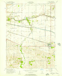
1953 Map of Atkinson
USGS Topo · Published 1957About this map
The village of Atkinson serves as a focal point in this mid-century look at central Henry County, where the industrial presence of the Chicago Rock Island and Pacific railroad meets a landscape shaped by hydraulic engineering. The Illinois and Mississippi Canal (abandoned) runs parallel to the rail line, indicating a shift from nineteenth-century water transport to twentieth-century rail and road dominance. To the north, the Green River meanders across the township boundaries of Phoenix and Loraine, while the surrounding prairie is dotted with a high density of rural institutions.
Find a feature on this map
26 named features on this map. Tap any name to fly to it.
Don’t see what you’re looking for? This feature index may not catch every label — zoom into the map to look around manually.
Map Details
Editions of this 1953 Atkinson Map
2 editions found
Other maps of this area

1899 · Clinton
USGS Topo · 1:125,000

1929 · Annawan
USGS Topo · 1:62,500

1932 · Prophetstown
USGS Topo · 1:48,000

1932 · Annawan
USGS Topo · 1:62,500

1934 · Geneseo
USGS Topo · 1:62,500

1936 · Prophetstown
USGS Topo · 1:62,500

1952 · Erie
USGS Topo · 1:62,500

1953 · German Corner
USGS Topo · 1:24,000
1953 · Geneseo
USGS Topo · 1:24,000
1953 · Cambridge
USGS Topo · 1:24,000