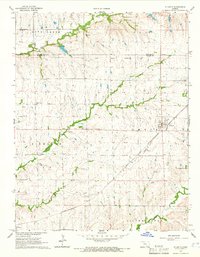
1964 Map of Atlanta
USGS Topo · Published 1966About this map
The town of Atlanta anchors this mid-century survey of the Kansas prairie, situated at the junction of the St Louis San Francisco railroad and the headwaters of Dutch Creek. A significant historical landmark, the Old Indian Treaty Boundary, cuts across the northern half of the landscape, marking a legacy of early territorial division. The region is defined by its rural character and extractive industry, notably the Fox Bush Field, Clay Field, and Combs Northeast Oil Field which dot the northern township lines.
Find a feature on this map
23 named features on this map. Tap any name to fly to it.
Don’t see what you’re looking for? This feature index may not catch every label — zoom into the map to look around manually.
Map Details
Editions of this 1964 Atlanta Map
This is the sole edition of this map. No revisions or reprints were ever made.
Other maps of this area

1888 · Eldorado
USGS Topo · 1:125,000

1889 · Burden
USGS Topo · 1:125,000

1955 · Wichita
USGS Topo · 1:250,000

1958 · Wichita
USGS Topo · 1:250,000

1961 · Gordon
USGS Topo · 1:24,000

1962 · Cambridge
USGS Topo · 1:24,000

1964 · Augusta SE
USGS Topo · 1:24,000

1964 · Latham
USGS Topo · 1:24,000

1964 · Cambridge NW
USGS Topo · 1:24,000

1964 · Burden
USGS Topo · 1:24,000