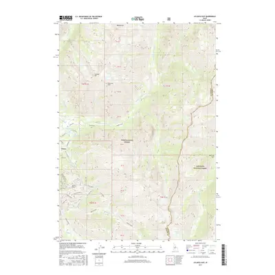
2017 Map of Atlanta East
USGS Topo · Published 2017About this map
Atlanta sits at the western edge of this 2017 high-country survey, marking a historic point of entry into the sawtooth peaks of the Boise National Forest and Sawtooth National Forest. The Middle Fork Boise River serves as the central artery of the landscape, fed by numerous high-altitude tributaries like Queens River and Mattingly Cr. Geothermal activity is evident near the settlement, with Atlanta Hot Springs and Chattanooga Hot Spring located along the riverbanks. The terrain is defined by massive elevations, including Blizzard Mtn and Greylock Mtn, while the map also documents localized infrastructure such as the Power Plant and various Forest Service routes like the Monarch Mill Spur and Flint Decker Loop. These features reflect a legacy of both resource extraction and backcountry recreation in Elmore County.
Find a feature on this map
49 named features on this map. Tap any name to fly to it.
Don’t see what you’re looking for? This feature index may not catch every label — zoom into the map to look around manually.
Map Details
Editions of this 2017 Atlanta East Map
This is the sole edition of this map. No revisions or reprints were ever made.
Other maps of this area

1894 · Rocky Bar
USGS Topo · 1:125,000

1900 · Sawtooth
USGS Topo · 1:125,000

1955 · Hailey
USGS Topo · 1:250,000

1959 · Hailey
USGS Topo · 1:250,000

1962 · Hailey
USGS Topo · 1:250,000

1964 · Ross Peak
USGS Topo · 1:24,000

1964 · Cayuse Point
USGS Topo · 1:24,000
1964 · Snowyside Peak
USGS Topo · 1:24,000

1964 · Marshall Peak
USGS Topo · 1:24,000
1970 · Newman Peak
USGS Topo · 1:24,000