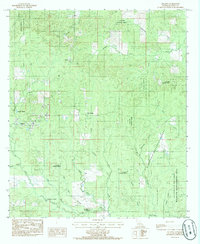
1984 Map of Atlanta
USGS Topo · Published 1985About this map
The town of Atlanta anchors this mid-1980s topographic study of the central Louisiana timberlands, where the landscape is defined by the dense reaches of the Kisatchie National Forest. The settlement pattern follows the drainages of numerous winding waterways, such as Hurricane Creek and the curiously named Port de Luce. To the east, the Catahoula National Wildlife Management Area borders the terrain, reflecting the region's dedication to conservation and managed wilderness.
Find a feature on this map
29 named features on this map. Tap any name to fly to it.
Don’t see what you’re looking for? This feature index may not catch every label — zoom into the map to look around manually.
Map Details
Editions of this 1984 Atlanta Map
This is the sole edition of this map. No revisions or reprints were ever made.
Other maps of this area

1932 · Colfax NE
USGS Topo · 1:31,680

1932 · Colfax NW
USGS Topo · 1:31,680

1935 · Verda
USGS Topo · 1:31,680

1936 · Colfax
USGS Topo · 1:62,500

1937 · Montgomery
USGS Topo · 1:62,500

1942 · Montgomery
USGS Topo · 1:62,500

1945 · Montgomery
USGS Topo · 1:62,500

1949 · Calvin SE
USGS Topo · 1:31,680

1949 · Calvin NE
USGS Topo · 1:31,680

1950 · Winnfield
USGS Topo · 1:62,500