
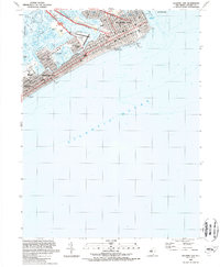
1989 Map of Atlantic City
USGS Topo · Published 1989About this map
Atlantic City and the neighboring shoreline of Ventnor City and Margate City are mapped here in high detail just as the casino era had firmly established its footprint. The famous Boardwalk stretches along the oceanfront, providing access to landmarks like the Steel Pier, Steeplechase Pier, and the Ocean One Shopping Mall. Inland, the complex geography of the Jersey Shore is revealed through the winding channels of Beach Thorofare and Inside Thorofare, which separate the primary barrier island from Chelsea Heights and Great Island. This survey captures the infrastructure of the late 1980s, including the Atlantic City Expressway terminus and the centrally located Muni Airport (Bader Field), offering a clear view of the urban grid before further modern redevelopment changed the skyline.
Find a feature on this map
32 named features on this map. Tap any name to fly to it.
Don’t see what you’re looking for? This feature index may not catch every label — zoom into the map to look around manually.
Map Details
Editions of this 1989 Atlantic City Map
2 editions found
Other maps of this area

1884 · Sea Isle
USGS Topo · 1:62,500

1887 · Atlantic City
USGS Topo · 1:62,500

1888 · Sea Isle
USGS Topo · 1:62,500

1890 · Great Egg Harbor
USGS Topo · 1:62,500

1893 · Great Egg Harbor
USGS Topo · 1:62,500

1894 · Sea Isle
USGS Topo · 1:62,500

1894 · Atlantic City
USGS Topo · 1:62,500

1918 · Great Egg Harbor
USGS Topo · 1:62,500

1919 · Sea Isle
USGS Topo · 1:62,500

1940 · Atlantic City
USGS Topo · 1:62,500