1953 Map of Atsion
USGS Topo · Published 1967About this map
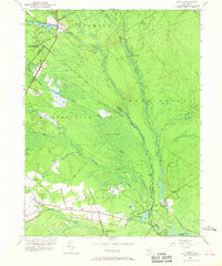
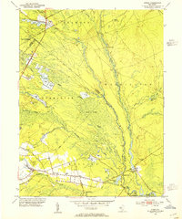
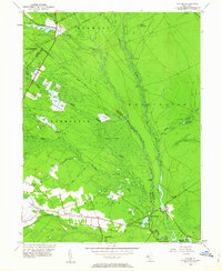
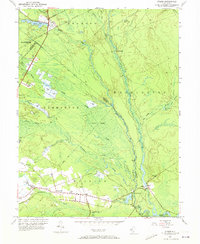
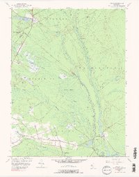
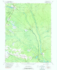
Cranberry Bogs dominate the low-lying wet topography of this Pine Barrens landscape, illustrating a specialized agricultural economy concentrated along the Sleeper Branch and Nescochague Creek. The Central RR of New Jersey cuts through the northwest corner at Atsion, where it intersects New Jersey Road, while the southern reaches of the sheet reveal small rural clusters like Nesco and Wescoatville. Historical industry is evident at Pleasant Mills and the isolated Lower Forge, points where the Batsto River and Mullica River provided the necessary water power for early iron and milling operations. The presence of the Nesco Sch and several cemeteries provide critical touchpoints for family historians tracing residents in these townships. Much of the interior remains undeveloped, defined by the Great Swamp and the Batsto area, where a Lookout Tower stands as a sentinel over the dense pine forests.
Find a feature on this map
49 named features on this map. Tap any name to fly to it.
Don’t see what you’re looking for? This feature index may not catch every label — zoom into the map to look around manually.
Map Details
Editions of this 1953 Atsion Map
6 editions found
Other maps of this area

1888 · Pemberton
USGS Topo · 1:62,500

1888 · Mount Holly
USGS Topo · 1:62,500

1890 · Hammonton
USGS Topo · 1:62,500

1890 · Mullica
USGS Topo · 1:62,500

1894 · Hammonton
USGS Topo · 1:62,500

1894 · Pemberton
USGS Topo · 1:62,500

1894 · Mount Holly
USGS Topo · 1:62,500

1894 · Mullica
USGS Topo · 1:62,500

1898 · Pemberton
USGS Topo · 1:62,500

1898 · Mount Holly
USGS Topo · 1:62,500
Featured Places
- Hammonton, NJ
- Tabernacle Township, NJ
- Mullica Township, NJ
- Washington Township, NJ
- Waterford Township, NJ