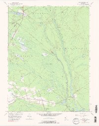
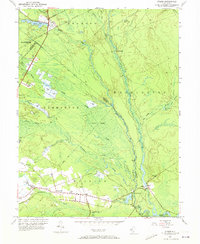
1953 Map of Atsion
USGS Topo · Published 1989About this map
Atsion sits at the northern edge of this mid-century survey, a landscape defined by the specialized agriculture and industrial history of the New Jersey Pine Barrens. The map reveals an extensive network of Cranberry Bogs following the many tributaries of the Mullica River, illustrating the region's reliance on wetlands and acidic soils. Near the southern boundary, the settlement of Batsto and the adjacent Pleasant Mills highlight historic centers of commerce along the Batsto River. Transportation in this era relied on the Central RR and the corridor of Route 206, which connects smaller hamlets like Dutchtown and Wescoatville. Geographers and local historians can trace the transition from natural features like the Great Swamp to managed landscapes, including a local schoolhouse at Nesco Sch and fire management infrastructure such as the Lookout Tower.
Find a feature on this map
48 named features on this map. Tap any name to fly to it.
Don’t see what you’re looking for? This feature index may not catch every label — zoom into the map to look around manually.
Map Details
Editions of this 1953 Atsion Map
6 editions found
Other maps of this area

1888 · Pemberton
USGS Topo · 1:62,500

1888 · Mount Holly
USGS Topo · 1:62,500

1890 · Hammonton
USGS Topo · 1:62,500

1890 · Mullica
USGS Topo · 1:62,500

1894 · Hammonton
USGS Topo · 1:62,500

1894 · Pemberton
USGS Topo · 1:62,500

1894 · Mount Holly
USGS Topo · 1:62,500

1894 · Mullica
USGS Topo · 1:62,500

1898 · Pemberton
USGS Topo · 1:62,500

1898 · Mount Holly
USGS Topo · 1:62,500
Featured Places
- Hammonton, NJ
- Tabernacle Township, NJ
- Mullica Township, NJ
- Washington Township, NJ
- Waterford Township, NJ