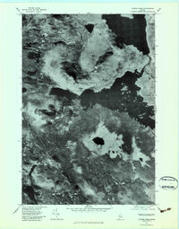
1977 Map of Attean Pond
USGS Topo · Published 1983About this map
Attean Pond and the surrounding wilderness of Somerset County are captured in this 1977 orthophotograph, providing a detailed look at the landscape just west of the settled corridor. The imagery highlights the relationship between the dramatic topography of Sally Mountain and the water bodies that define the region's geography. To the north, Jackman Station marks a point of human activity near the southern reaches of Wood Pond, while the winding course of the Moose River meanders across the southern half of the sheet. This photographic survey preserves the exact state of the forest and shoreline before modern developments, showing the remote character of Attean Mountain and smaller features like Whipple Pond and Benjamin Brook.
Find a feature on this map
10 named features on this map. Tap any name to fly to it.
Don’t see what you’re looking for? This feature index may not catch every label — zoom into the map to look around manually.
Map Details
Editions of this 1977 Attean Pond Map
This is the sole edition of this map. No revisions or reprints were ever made.
Other maps of this area

1922 · Long Pond
USGS Topo · 1:62,500

1923 · Attean
USGS Topo · 1:62,500

1924 · Long Pond
USGS Topo · 1:62,500

1925 · Pierce Pond
USGS Topo · 1:48,000

1925 · Attean
USGS Topo · 1:62,500

1927 · Pierce Pond
USGS Topo · 1:62,500

1928 · Spencer
USGS Topo · 1:48,000

1932 · Spencer
USGS Topo · 1:62,500

1944 · Long Pond
USGS Topo · 1:62,500

1944 · Pierce Pond
USGS Topo · 1:62,500