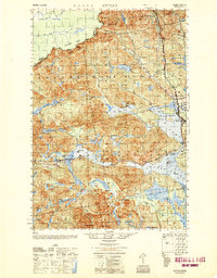
1950 Map of Attean
USGS Topo · Published 1950About this map
The Canadian Pacific railway cuts through this northern wilderness, connecting small railroad-oriented settlements like Holeb and Jackman Station. At mid-century, this area of Somerset County served as a rugged interface between the United States and Canada, with the Canada United States border running along the northwestern height of land. The landscape is defined by its water systems, notably the massive Attean Pond and Wood Pond, which supported the local economy of the Jackman region. Land-use markers such as Boston Ranch and the isolated No 5 Farm indicate pockets of agricultural activity amid the heavy timberlands. Further up the Moose River, the small settlement of Dyerville and the Stetson Sch reflect the sparse but established social infrastructure for the families living near the northern reaches of the Sally Mountain range.
Find a feature on this map
69 named features on this map. Tap any name to fly to it.
Don’t see what you’re looking for? This feature index may not catch every label — zoom into the map to look around manually.
Map Details
Editions of this 1950 Attean Map
2 editions found

Other maps of this area

1922 · Long Pond
USGS Topo · 1:62,500

1923 · Attean
USGS Topo · 1:62,500

1924 · Long Pond
USGS Topo · 1:62,500

1925 · Pierce Pond
USGS Topo · 1:48,000

1925 · Attean
USGS Topo · 1:62,500

1927 · Sandy Bay
USGS Topo · 1:48,000

1927 · Pierce Pond
USGS Topo · 1:62,500

1928 · Chain Lakes
USGS Topo · 1:48,000

1928 · Skinner
USGS Topo · 1:48,000

1928 · Spencer
USGS Topo · 1:48,000